Press Release: Support Gateway Communites Application

LAKE CITY, COLO., (February 8, 2019) – Gateway Communities are found along the Continental Divide Trail and recognize the unique economic and cultural values this trail brings. There is no cost for the designation. The program focuses on supporting these Gateway Communities in stewardship and promotion of the trail and building a strong trail community. The Town of Lake City voted to provide a letter of support for this application driven by citizens and local businesses.

Please lend your support of our Gateway Community application by sending us an email (our internal deadline is February 12th so we can submit our application by mid-February). And let us know if you’d like to be involved in these efforts as we move forward with a work group.

Lake City DIRT is a leader in the Colorado Main Street program, in partnership with our local governments, other nonprofit organizations, small business owners, donors, and volunteers. More information can be viewed at www.lakecitydirt.com


Press Release: Lake City Uncorked Wine & Music Festival Lineup 2019

2019 Music Lineup Released for the Lake City Uncorked Wine & Music Festival

LAKE CITY, CO (February 1, 2019): The Lake City DIRT Board of Directors is pleased to release the 2019 Music Lineup for the September 21st Lake City Uncorked Wine & Music Festival in downtown Lake City. More info www.lakecitydirt.com

Lake City’s own Jeff Heaton is a classically trained singer and a self-taught guitar player. He has an eclectic sound with the styles of James Taylor, John Denver, Gordon Lightfoot, and Merle Haggard. Jeff often says that he likes good music regardless of the genre and/or the artist. In the last few years, Jeff has opened for Michael Martin Murphey, Asleep at the Wheel, The Bellamy Brothers, Johnny Lee, Suzy Bogguss, Johnny Rodriguez, Exile, Restless Heart, Hal Ketchum and Marty Haggard. Jeff’s repertoire is a collection of songs that tell a story and will pull at your heartstrings. After all, the words are half of the song. Jeff has recorded 2 CDs, one titled ‘Just Chillin’, which is a cover collection of Jeff’s favorite songs and some of his own. The second CD is titled ‘Warm Wishes, A Chillin’ Christmas’, which includes Jeff’s favorite Christmas songs as well as some gospel songs.

Shavano Blues Trio plays a wide range of blues, rhythm and blues, and jazzy blues from the ‘40s to the present day. Powerful, sultry vocals in combination with rhythmic stand-up bass and classic blues keys make this trio a blues lover’s dream. Shavano Blues Trio will rock your soul with its unique renderings of songs by the likes of Ray Charles and Bonnie Raitt, Aretha Fanklin, Koko Taylor, and Etta James, as well as original songs like Close My Windows and Run Me Ragged. Shavano Blues Trio has played a variety of clubs and festivals in the mountains and on the Front Range including the Greeley Blues Jam; The Boathouse, Benson’s, Vino Salida, Soul Craft Brewery, Thursdays at 6, Brewers Rendezvous, and FibArk in Salida; El Chapultepec, Denver; The Boulder Outlook; Western State Music Series, High Alpine Brewery, and Sundays at 6 in Gunnison; The Crested Butte Arts Festival; as well as private parties, weddings and corporate functions.

Welcome back to Lake City, Lisa Morales started penning tunes to express her emotions addressing the complex landscape of relationships. Her perspective now is that of a woman who’s gone through many storms and witnessed their sometimes-beautiful aftermaths as well. With Luna Negra and the Daughter of the Sun, Morales sought to reach even more deeply into her soul. Drawing from a creative palette informed by the rhythms, colors and flavors of the Southwest — from the painted-desert skies of her native Tucson, Arizona, where she and cousin Linda Ronstadt grew up, to the sea-salted air of Houston, where she moved at 18, and the history-filled city of San Antonio, where she now lives. Lisa Morales confirms that she is a woman in touch with her emotions and inner power. Morales recorded six albums as one-half of the duo Sisters Morales before releasing her solo debut, Beautiful Mistake, in 2012. Lisa has also worn a producer’s hat with highly acclaimed production on Hayes Carlls’ “Flowers & Liquor; co-wrote “Waiting For the Stars to Fall” with Hayes Carll on his CD “Trouble In Mind”. She is a favorite on the Uncorked stage.

Honeyhouse is a unique acoustic trio combining the talents of three very diverse and seasoned artists into one unexpected powerhouse force. Consisting of award-winning R&B/Gospel soulstress Hillary Smith, earthy Blues/Folk singer-songwriter Yvonne Perea, and sweet voiced Mandy Buchanan, “hONEyhoUSe” seamlessly melds the lines of musical genres with their original creations embracing blues, soul, folk and Americana into one sweet Honeyhouse of music. Three very different voices with one path…hONEyhoUSe. With a deep soulfulness rooted in the Gospel-driven churches of her youth, Hillary Smith is a classically trained vocal instrument that’s a natural wonder and a God-given instinct for swinging a lyric. She’s a belter, but her voice also possesses great warmth and expressiveness, and she is able to get under the skin of those in her audience. With a seamless merging of folk, blues, and rock, Yvonne Perea’s music captures her audience through her memorable melodies, relevant lyrics, and soulful earthy vocals. After hearing Yvonne or watching her perform live, you come away with the feeling that you’ve really seen a glimpse of Yvonne’s soul.

Red River songbird, Mandy Buchanan always delivers a moving, powerful performance whether she is singing with a lone guitar player or a full band, lead vocals or harmonies. Surrounded by a family of musicians, Mandy began singing in church at an early age. From country to blues, jazz to rock and roll, her sweet voice will take you by surprise when you least expect it.

“Some people are impressionists. These guys leave an impression”. Says Bill Miller, owner of Johnny Cash.com about Cash’d Out (Douglas Benson vocals, George Bernardo drums, John Heussenstamm guitar, Nate Lefranchi bass), a Lake City favorite band that channels Johnny Cash in about as close a manner to the real thing as it gets. After 13 years, traveling hundreds of thousands of miles on the road and winning over as many fans, fans who still continually tell the group how grateful they are that Cash’d Out so righteously carries the torch of the Johnny Cash Show. Besides music critics anointing Cash’d Out as “the next best thing to Johnny Cash”, their highlights have been many: W.S. Holland, Johnny Cash’s longtime drummer, has sat in with Cash’d Out; front man, Douglas Benson, has played Johnny’s cherry sunburst Guild guitar (courtesy of Mr. Miller); “Cindy Cash came to a show and was moved to give me a glass locket that was her father’s,” explains Benson; Longtime Johnny Cash manager Lou Robin has also been to several Cash’d Out shows and claimed that if he closed his eyes it was as if “going back in time.”; And most recently, an unforgettable evening performing the music of Johnny Cash with the San Diego Symphony as a special event for their Summer Pops Series. The band’s live shows respectfully reference the late, great Man in Black’s Sun Records and early Columbia era sound, combined with the energy of the classic multi-platinum live recordings from Folsom Prison and San Quentin. The group’s genuine love (and authentic recreation) of Johnny Cash’s music and its universal appeal fans of all ages and of virtually all musical genres makes each Cash’d Out show a must-see event.

Mo’Champipple & the Meso Horns
Music provided between acts by Bruce Hayes who plays a fusion of the musical styles that combine acoustic and electric instruments with elements of rock, bluegrass, celtic, and R&B. Collaborating with The String Cheese Incident and Acoustic Junction, Hayes helped define the acoustic jam band sound. He continues this tradition performing original songs and arrangements on mandolin, guitar, dobro, foot board, and more.

More information and links to bands can be found at lakecityfestival.org

Main Street America Community Spotlight: Lake City, Colorado

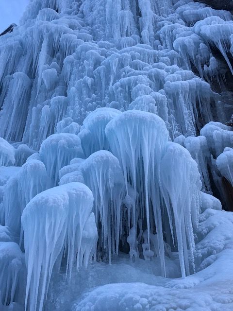
January 16, 2019 | Community Spotlight: Ice Climbing on Main Street


Photo credit: Benjamin Hake

Nestled in the heart of the San Juan Mountains is the tiny town of Lake City, Colorado. With more than 50 miles to the nearest town, this small Main Street community is implementing innovative strategies to keep their 400 year-round residents busy and to draw tourists to the area. The Lake City Ice Wall endeavor started a dozen years ago with a few hardy volunteers farming the ice. Free and open to the public, it is located by permission on public land and is adjacent to city limits and the Main Street boundary.

The ice wall boasts 10-15 routes, 60-100 foot pitches, bolster anchors, and mixed grades. There is a warming hut and you can typically find a crackling wood fire to warm up. Outdoor activities abound in the winter in Hinsdale County, which is the most remote in the Lower 48 states and one of the few places you can wander for more than 10 miles from a road or trail.

With 97% of public land used for year-round recreation, there’s plenty of activities to do: 100 miles of groomed snowmobile and cross country skiing trails, a ski hill and terrain park with a Poma lift, a back-country haute route, ice fishing, and pond hockey tournaments. A new brewery, unique retail shops, and restaurants can be found in Historic Downtown Lake City, located just a block away from the Ice Wall.

Lake City DIRT runs the Main Street program and is one of three graduate communities in the state. For more information, visit www.lakecitydirt.com.

Permalink

https://www.mainstreet.org/blogs/national-main-street-center/2019/01/16/community-spotlight-ice-climbing-on-main-street

The National Main Street Center, Inc.
53 West Jackson Blvd., Suite 350
Chicago, IL 60604

Main Street America has been helping revitalize older and historic commercial districts for more than 35 years. Today it is a network of more than 1,600 neighborhoods and communities, rural and urban, who share both a commitment to place and to building stronger communities through preservation-based economic development. Main Street America is a program of the nonprofit National Main Street Center, Inc., a subsidiary of the National Trust for Historic Preservation.

© 2018 The National Main Street Center. All Rights Reserved.

The Most Remote US Counties – Using Roads by Aaron O’Neill of Mapping Americana

I’ve lived in six different locations throughout my life. All of them were within 30 miles of the nearest major city, and each one had at least one interstate running through the county. I suspect this is the case with most Americans; after all, while our country is filled with wide open spaces, more and more of us are flocking to urban areas.

The urban migration. Via Governing Magazine.

Still, the wilderness has a certain appeal to it. It’s nice to imagine losing yourself in the middle of nowhere, where there are less mundane responsibilities and time seems to move slower. The contrast between urban and rural areas in the US got me thinking: what was the most remote place in America? This question has been asked before, with varying answers. However, I will get one thing out of the way: obviously, Alaska has many of this nation’s most remote locales. So, for these particular posts, I’ll be excluding Alaska and Hawaii.

So, what makes a place remote? Is it its distance from the nearest major population center? Its distance from the next town of any population? Perhaps it’s the difficulty of getting there, through the lack of efficient road networks. In my opinion, remoteness can mean all of these things. So, over the next couple of weeks I’ll be finding the most remote places in America by looking through different lenses. I’ll begin today by looking at the USA’s road network.

NB77SB81

These shields will come in handy later. Via Wikimedia Commons.

America has one of the best road systems in the world, and it’s easy to get pretty much anywhere with a standard car. Still, there are some places that remain on the fringes of the network. Today, I’ll look at the counties that are the farthest removed from the country’s main arteries, using my own (very unscientific) methodology. I’ll be using a process of elimination to figure out the most remote counties to get to by car.

First, we can eliminate any counties that have interstates running through them. This automatically gets rid of over 40% of the nation’s counties, but we’re still left with well over 1,000. So, let’s also eliminate any county that contains a federal highway. In short, we’re treating any roads that bear the famous white or blue shield as major arteries. This still leaves us with over 250 “remote” counties.

The first round of cuts.

There are some interesting observations to be made from the above map. First of all, just because a road isn’t federally maintained doesn’t necessarily mean that it’s not a major artery. For example, in California’s Central Valley, State Road 99 is the major highway for large cities such as Visalia (see map). However, under my criteria some of these clearly urban counties still count as “remote.” The same applies in New Jersey: Cumberland County (see map) is considered “remote” despite containing several cities and the main highway between Philadelphia and the shore. Clearly, I had to dig deeper.

My next round of elimination focused on proximity to interstates. If a county’s neighbor contained an interstate, that county was eliminated. I figured that most people living in these counties would still have a relatively easy drive to get onto the highway. After this next round of eliminations, the map looked like this:

Getting more remote…

Now, that’s much better. The number of “remote” counties was cut to just 70, and many of them were in places you might expect: the Appalachians, the Ozarks, and the sprawling Great Plains. Of course, this methodology wasn’t perfect. It eliminated many of the larger counties in the more rugged west, while preserving counties like Nantucket and Dukes in Massachusetts (see map) that were fairly close to urban centers. Still, I was making progress. Time to dig deeper.

My next round of eliminations focused on Google Maps. In short, Google divides its roads into three colors: Orange, yellow, and white. Orange was typically reserved for freeways, while yellow roads denoted intermediate local routes. I figured that if a county only had white roads on Google, it was more remote than its counterparts. This process cut the map down significantly once again. Take a look:

Much better.

This final map shows the 12 most remote counties in the United States, according to the road system. I was surprised at the representation of the Chesapeake region in this final map – guess my trip to St. Mary’s County last week wasn’t enough to drive home how out-of-the-way this area was. In many ways, though, this map is exactly what I expected. I knew that the West would be underrepresented due to the size of the counties, and I knew that many Appalachian and Atlantic counties relied on small local roads.

Now, it was time to figure out which of these 12 counties was the most remote. I looked at each remaining county to determine which one had the least state roads running through it. After all, if a county had to maintain all of its own roads, it was essentially forgotten by the rest of the road system. Through this method, I reached a surprising conclusion. Both Dukes and Nantucket Counties in Massachusetts had no state roads! Despite being located less than 100 miles from Boston, these counties were the farthest removed from the road system. I suppose this made sense, since both required ferry access. Still, it felt like cheating.

MV Nantucket August 2017

It just feels wrong. Via Wikimedia Commons.

So, I looked for the next best candidate. The result was clear: Hinsdale County, Colorado (see map) only had one road running through it. And I don’t mean one state road, either. Hinsdale literally only has one paved thru-road running through it, the Silver Thread Scenic Byway. I’d driven this road before, and I can attest to the sheer wildness of the county. I feel confident declaring Hinsdale the winner. Despite the East’s best efforts, the wild West still prevails.

Empire Chief mine, 2001

Scenes from Hinsdale County. Via Wikimedia Commons.

www.mapamericana.com/2018/07/21/the-most-remote-us-county-using-roads

Burrows Park (Park) District Mining Information

Hinsdale County

Burrows Park District (aka Whitecross District; aka Park District)

This district is possibly an amalgamation of several districts, but at least has several names. Henderson provides very a very specific location for the Park District, listing 16 sections in three different townships that appear to be the same as other descriptions of the Whitecross/Burrows Park District. Dunn (2003) indicates that the Burrows Park District may have originally been known as the Park District, which seems to fit with Henderson’s description. She notes that Hinsdale County was divided into six districts by the state legislature in 1893, of which the Park District was one, along with the Carson, Cimarron, Galena, Lake, and Sherman Districts. Mindat.org (Sep 2015) considers the Burrows Park, the Park and the Whitecross to be the same district, a convention we follow here.

Vanderwilt (1947) considered the Burrows Park District, which he described as sitting at the head of the Lake Fork of the Gunnison River, to be a continuation of the mineralization of the Silverton area. Wilson and Spanski (2004) aggregated the Burrows Park District in with eight other districts as the “San Juan Mineralized Area.” The connection is that they appear to lie within the San Juan caldera of Steven and Lipman (1976). (The other districts in this grouping are the Galena/Henson Creek, the Sneffels, South Ouray, Eureka, Telluride, Ophir, Red Mountain and Lower San Miguel, of which the Galena is in Hinsdale County.)

The geology consists of tuffs and flows associated with the Oligocene San Juan caldera complex, with an outlier of Precambrian granites in the middle (Vanderwilt, 1947). Mineralization consists of “filled fissures grading into replacement types” of chalcopyrite ore, sphalerite-galena ore or gold-silver ore with small amounts of lead and zinc (Vanderwilt, Ibid).

Eberhart (1969) discusses the three settlements that arose around Cinnamon Pass – Whitecross, Tellurium and Sterling. He indicates that the harsh winters and associated transportation problems inhibited both the mines and the towns.

Mines listed in the district (mindat.org; Eberhart, 1969; Dunn, 2003) include:
 Allen Dale2
 Bon Homme Tunnel1, 2
 Burrows Park Group1
 Champion2
 Cleveland Group (Hilluron Millsite; Ida; Lock Lommond)1
 Cracker Jack2
 Dewey1
 Gavin Pipe Occurrence1
 Gnome Mine (Bull Run; Bull Run No. 1; Unpatented Claims: Sydney Nos. 1-3;
Gnome Nos. 1-26; Patented Claim: Gnome)1
 Goodwin1
 Goodwin’s Creek1
 Illinois Boy Mine (Patented Claim: Illinois Boy)1
 Isolde Mine (Belcher; Baltimore; Isolde)1
 Little Sarah2
 Monticello Mine1
 Mountain King2
 Napoleon Mine (Patented Claim: Napoleon)3
 Ohio Mine1
 Onida3
 Park View Mine (View of the Park Mine; D & N Lead Mining Company Nos. 1-4)1
 Providence2
 Seward County Mine (Patented Claim: Seward County)1
 Silver Star Mine (Patented Claim: Silver Star)1
 Tobasco2
 Troy2
 Undine3
 Whitecross Mountain1
Notes: 1 Mines listed in mindat.org, September 2015.
2 Mines listed by Eberhart (1969), as located near the settlements around Cinnamon Pass.
3 Mines listed by Dunn (2003).
Minerals listed in the district (mindat.org) include:
Brochantite
Calaverite
Calcite
Chalcopyrite
Galena
Lillianite
Molybdenite
Opal var: Opal-AN
Platinum
Pyrite
Quartz
Sphalerite
Tetrahedrite
References:
Dunn, Lisa. 2003. Colorado Mining Districts: A Reference. Colorado School of Mines, Golden, Colorado.
Eberhart, Perry. 1969. Guide to Colorado Ghost Towns and Mining Camps. Fourth, revised edition. Swallow Press, Athens, Ohio.
Henderson, C.W. 1926. Mining in Colorado, a history of discovery, development and production. U.S. Geological Survey Professional Paper 138.
Steven, T.A. and Lipman, P.W. 1976. Calderas of the San Juan Volcanic Field, Southwestern Colorado. U.S. Geological Survey Professional Paper 958.
Vanderwilt, John W. 1947. Mineral Resources of Colorado. Colorado Mineral Resources Board, Denver, Colorado.
Wilson, A.B. and Spanski, G.T. 2004. Distribution of Mines and Mineralized Areas in Bankey, V., ed. Resource Potential and Geology of the Grand Mesa, Uncompahgre, Gunnison National Forest and Vicinity, Colorado. U.S. Geological Survey Bulletin 2213.
www.mindat.org, accessed September 2015.

This information is from the Colorado Geological Survey website at http://coloradogeologicalsurvey.org

Lake City (Lake) Mining District Information

Hinsdale County

Lake City District (aka Lake District; aka Lake Fork District)

The Lake City District has been identified as the Lake, the Lake City and the Lake Fork District. These districts are occasionally differentiated, but here we include all as the same district, extending south to Lake San Cristobal.

The Lake District was one of the six districts into which the Colorado legislature divided Hinsdale County in 1893. (The others were the Carson, Cimarron, Galena, Whitecross and Sherman Districts.) The district occupies the Lake City, Uncompahgre Peak and Redcloud Peak quadrangles.
Lake overlaps (or blends into) the major district to the west, the Galena or Henson Creek District. Mindat.org separates the Lake and the Galena into two districts. The seminal work on the area – Irving and Bancroft (1911) does not distinguish the different districts, but rather discusses mines in the vicinity of Lake City.

Mindat.org and Dunn (2003) list the group of mines (the Hidden Treasure, Ute and Ulay) among the most famous and productive in the Lake City District. However, Irving and Bancroft (Ibid) lists them among the “Henson Creek Mines,” which implies Henson Creek (Galena) District. Vanderwilt (1947) places these mines in the Galena (Henson Creek) District also, and provides a structural distinction between the two districts, noting that a down-faulted block lies between Henson Creek and Lake Fork. We have chosen to make the distinction as mindat.org does to make referencing the mines easier for the reader.

Irving and Bancroft (Ibid) distinguish a group of mines as the San Cristobal Group, south of Lake City – a geographic distinction that we believe places those mines in the Lake City district.
The geology of the Lake City District is typical of the San Juan Mountains. The district sits within the caldera fill on the northeast margin of the Lake City Caldera (Steven and Lipman, 1976; Wilson and Spanski, 2004). Units include Oligocene quartz latite and andesitic flows and breccias of significant lateral extent, plus more localized flows; the Bachelor Mountain and Carpenter Ridge tuffs, the Fish Canyon tuff, the La Garita tuff, the Henson and Burns formations, the Sapinero Mesa, Eureka and Dillion Mesa tuffs along with silicic lavas (Day et al., 1999). Generalized descriptions are also available in Sanford et al. (1987).

Mineralization was described generally by Vanderwilt (Ibid) as vein mineralization continuous with that of the Silverton area. Bove et al. (2000) distinguish 23 Ma precious metal-bearing barite veins and older base-metal veins. Irving (1905) and Irving and Bancroft (1911) provide a detailed descriptions of the rocks and mineralization.

Some top-producing mines include the Golden Fleece (nee Hotchkiss) mine, discovered in 1874, which produced $1.4M in metals (Henderson, 1926). The Pelican Mine produced off and on from 1891 to 1960; Irving and Bancroft (Ibid) report freibergite, pyrargyrite and galena as the main minerals. The Fanny Fern Mine produced silver from tetrahedrite, reporting 74,000 ounces of silver and 65 ounces of gold.

The Black Crook Mine operated off and on until 1953. The Contention Mine was another major producer.

The Ute and Ulay veins are names that always appear in relation to the mines and deposits of the Lake City area. The Ute was the most productive and important of all the mineral veins in the district (Irving and Bancroft, Ibid). The vein was traced for 2,700 feet along outcrop. The vein described an arc, concave to the northwest, averaging four feet in width, but pinching and swelling and occasionally splitting. The vein sequentially filled first with quartz, then rhodochrosite/tetrahedrite/galena and then more quartz. Later movement shattered the vein material and deposited more quartz and barite. The ore mineralization was (presumably, because it was mostly gone even before Irving and Bancroft visited) argentiferous galena with subsidiary tetrahedrite, sphalerite, pyrite and enrichments of ruby silver (proustite/pyrargyrite – Ag3AsS3- Ag3SbS3). Further details are available in Irving and Bancroft (Ibid).

A unique situation has been identified at the Golden Wonder Mine. Irving and Bancroft (Ibid) recognized it as the “only true replacement deposit” in the Lake City area. It was recognized as a hot spring deposit in the 1980’s (Billings, 1983; Billings and Kallowkoski, 1982; Kalliokoski and Rehn, 1987), described as a small epithermal alunitic gold and base metal deposit within flow-foliated rhyolite. The deposit contains considerable gold (often microscopic native gold) and maintains an active permit with the State of Colorado as of 2015 for LKA Gold Incorporated.

Early activity did not develop until the Brunot Treaty of 1873 with the Ute tribe allowed worry-free entry into the territory. The Ute-Ulay discovery had been made in 1871, but not developed until the treaty was in place (Eberhart, 1969). Lake City was the first settlement, named for Lake San Cristobal. Many colorful characters passed through the town, including Alfred Packer, the famous Colorado cannibal.

Mines listed in the district (mindat.org and others) include:
 Belle of the West Mine (Malter Placer; Western Belle; Delphos; Trenton; Extension; Patented Claims: Belle of The West)
 Black Crook Mine (Ilma-Hiwassee group; Ilma Mine; New Year)1
 Cleveland Mine
 Contention Mine (Patented Claims: Contention; Mayflower)1
 Dauphin1
 Dawn of Hope
 Eckman Manganese Deposit
 Evangeline claim
 Fanny Fern Mine (Mayday Lode; J. C. Lode; Springfield; Unpatented Claims:
Fanny Fern No. 2; Patented Claim: Fanny Fern; B. R. Lode)
 Ferrara Ranch
 Galena
 Garlock mine
 Gladiator Mine (Ore House; Gladiator; Montana Nos. 1-9)
 Gold Quartz Mine (Wells Mine; Patented Claim: Red Cloud; Gold Quartz Nos. 1-6; Unpatented Claim: Gold Quartz)
 Golden Wonder Mine1, 2
 Happy Day
 I.D.A. Occurrence
 Ilma Mine
 L-C Property (Lake City Property)
 Lake City
o Belle of the East Mine
o Golden Fleece Mine1
o Governor Pitkin Mine
o Hidden Treasure Mine1
o Hotchkiss lode
o Ocean Wave Mine
o Oulay Mine (Ulay Mine; Ute-Ulay Mine)1
 Lake Fork River
o Monte Queen Mine
 Lode Star1
 Louise Morrell Lode Nos.1 & 2
 Mable
 Matterhorn Peak Area
o Dix and Cimarron Chief Groups
 Missouri Favorite Mine1
 Monte Queen1
 Nellie M. Mine (Patented Claim: Nellie M.)1
 Ottawa Mine1
 Pelican Mine1
 Red Mountain Alunite Deposit
 Risorgimento Mine (Patented Claim: Risorgimento)
 Rodney No. 1
 Silver Creek
 St. Mary’s Mining Company Property (V.C.)
 Sulphuret Mine (Cora; Patented Claims: Sulphuret; Sulphuret-Cora Mine)1
 Sunshine Peak tuff
 Uncompahgre Peak
 Uncompahgre Peak Prospect (Maurell Claim)
 Ulay1
 Ute1
Notes: 1Detailed description of mine contained in Irving and Bancroft (1911).
2Considerable information on mine (refer to bibliography).
Minerals listed in the district (mindat.org) include:
Acanthite
Aikinite
Altaite
Alunite
Ankerite
‘Apatite’
Arsenopyrite
Azurite
Baryte
Bismuthinite
Bornite
Boulangerite
Bournonite
Calaverite
Calcite
Chalcopyrite
Chalcostibite
‘Chevkinite’
Coloradoite
Colusite
Copper
Covellite
Dickite
Emplectite
Enargite
Epidote
Fluorite
Freibergite
Galena
var: Argentiferous Galena
Gold var: Electrum
Gypsum var: Selenite
Hematite
Hessite
Hinsdalite (TL)
Jamesonite
Kaolinite
Krennerite
Lead
‘Limonite’
Luzonite
Magnetite
Malachite
Marcasite
Matildite
Mawsonite
Melanterite
Melonite
Molybdenite
Molybdite
Muscovite var: Sericite
Natrolite
Pearceite
Petzite
Pilsenite
Polybasite
Proustite
Pyrargyrite
Pyrite
Pyroxmangite
Quartz
var: Chalcedony
var: Jasper
Rhodochrosite
‘Schirmerite’
Silver
Smithsonite
Sphalerite
Stephanite
Stibnite
Stützite
Svanbergite
Sylvanite
Tellurium
Tellurobismuthite
Tennantite
Tetrahedrite
var: Argentian Tetrahedrite
var: Zincian Tetrahedrite
Uraninite var: Pitchblende
Volynskite
Wurtzite
References:
Billings, Patty. 1983. Underground Geologic Maps of the Golden Wonder Mine, Lake City, Hinsdale County, Colorado. U.S. Geological Survey Open-File Report 83-907.
Billings, P. and Kalliokoski, J. 1982. Alteration and Geologic Setting of the Golden Wonder Mine, Western San Juan Mountains, Colorado. Geological Society of America Abstracts with Programs, vol. 14, pp. 443-444.
Bove, D.J., Hon, K., Budding, K.E., Slack, J.F., Snee, L.W. and Yeoman, R.A. 2000. Geochronology and Geology of Late Oligocene Through Miocene Volcanism and Mineralization in the Western San Juan Mountains, Colorado. U.S. Geological Survey Open-File Report 99-347.
Day, W.C., Green, G.N., Knepper, D.H., Jr., and Phillips, R.C. 1999. Spatial Geologic Data Model for the Gunnison, Grand Mesa, Uncompahgre National Forests Mineral Assessment Area, Southwestern Colorado and Digital Data for the Leadville, Montrose, Durango, and Colorado Parts of the Grand Junction, Moab, and Cortez 1 degree x 2 degrees Geologic Maps. U.S. Geological Survey Open-file Report 99-427.
Dunn, Lisa. 2003. Colorado Mining Districts: A Reference. Colorado School of Mines, Golden, Colorado.
Eberhart, Perry. 1969. Guide to Colorado Ghost Towns and Mining Camps. Fourth, revised edition. Swallow Press, Athens, Ohio.
Henderson, C.W. 1926. Mining in Colorado, a history of discovery, development and production. U.S. Geological Survey Professional Paper 138.
Irving, J.D. 1905. Ore Deposits in the Vicinity of Lake City, Colorado in Emmons, S.F. and Eckel, E.C., Contributions to Economic Geology, 1904. U.S. Geological Survey Bulletin 260.
Irving, J.D. and Bancroft, H. 1911. Geology and Ore Deposits near Lake City, Colorado. U.S. Geological Survey Bulletin 478.
Kalliokoski, J. and Rehn, P. 1987. Geology of the Veins and Vein Sediments, of the Golden Wonder Mine, Lake City, Colorado: an Epithermal Hot Springs Gold-Alunite Deposit. U.S. Geological Survey Open-File Report 87-344.
Sanford, R.F., Grauch, R.I., Hon, K., Bove, D.J., Grauch, V.J.S., and Korzeb, S.L. 1987. Mineral Resources of the Redcloud Peak and Handies Peak Wilderness Study Areas, Hinsdale County, Colorado. U.S. Geological Survey Bulletin 1715-B.
Steven, T.A. and Lipman, P.W. 1976. Calderas of the San Juan Volcanic Field, Southwestern Colorado. U.S. Geological Survey Professional Paper 958.
Vanderwilt, J.W. 1947. Mineral Resources of Colorado. Colorado Mineral Resources Board, Denver, Colorado.
Wilson, A.B. and Spanski, G.T. 2004. Distribution of Mines and Mineralized Areas in Bankey, Viki, ed. Resource Potential and Geology of the Grand Mesa, Uncompahgre, and Gunnison (GMUG) National Forests and Vicinity, Colorado. U.S. Geological Survey Bulletin 2213-E, p. 67-86.
www.mindat.org, accessed September 2015.

This information is from the Colorado Geological Survey website at http://coloradogeologicalsurvey.org

Sherman Mining District Information

Hinsdale County

Sherman District (aka Park District)

The Sherman District was one of the six districts into which the Colorado legislature divided Hinsdale County in 1893. (The others were the Galena, Cimarron, Lake, Whitecross and Carson Districts.) The location of the Sherman District is not well defined. Henderson (1926) indicates that the Park District overlaps the Sherman District. He provided a specific location for the Park District that appears to include the area we have enclosed in the Burrows Park District. He does indicate that it overlaps the Sherman District. Dunn (2003) distinguishes the two districts, with the Park District on the Lake Fork of the Gunnison River and the Sherman in the vicinity of the ghost town of Sherman. Mindat.org calls the two districts the same and places both south of the Cinnamon Pass area, which we have placed in the Burrows Park District. In general, we place the Sherman District (aka Park District) south of Handies Peak, to the area around Cottonwood Creek.

Dunn (Ibid) assigns the Black Wonder, Washington and Vermont mines to the Sherman District and the Illinois Boy, Champion and Grand Republic to the Park District. We have placed the Illinois Boy and Champion in the Burrows Park District.

The geology is generally described in Lipman (1976) and Lipman et al. (1976), summarized in Sanford et al. (1987) as lying in the area of the San Juan and Lake City calderas. Rocks included are Sapinero Mesa tuff and megabreccia, Precambrian granite representing the terrain in which the calderas formed, along with post-breccia lava flows and fill.

Mineralization is similar to the other Hinsdale County districts, with predominately veins carrying gold and silver, and some base metals. Sanford et al. (Ibid) found potential for precious and base metals, and porphyry molybdenum.

Mines listed in the district (mindat.org) include:
 Black Wonder Mine (Black Wonder Extension; Black Wonder No. 2; Patented Claims: Black Wonder)
 George Washington Group (Patented Claims: George Washington; No. 2 Ruby)
 Minnie Lee Mine (Patented Claims: Minnie Lee; Minnie Lee Mill Site; Morning Star)
 Sterling Group
Minerals listed in the district (mindat.org) include:
Acanthite
‘Apatite’
Chalcopyrite
Colusite
Covellite
Galena
‘Monazite’
Pyrite
Quartz
Rhodochrosite
Sphalerite
Tennantite
Tetrahedrite
Thorite
References:
Dunn, Lisa. 2003. Colorado Mining Districts: A Reference. Colorado School of Mines, Golden, Colorado.
Eberhart, Perry. 1969. Guide to Colorado Ghost Towns and Mining Camps. Fourth, revised edition. Swallow Press, Athens, Ohio.
Henderson, C.W. 1926. Mining in Colorado, a history of discovery, development and production. U.S. Geological Survey Professional Paper 138.
Lipman, P.W. 1976. Geologic Map of the Lake City Caldera Area, Western San Juan Mountains, Southwestern Colorado. U.S. Geologic Survey Miscellaneous Investigation Series Map I-962. Map Scale: 1:48,000.
Lipman, P.W., Fisher, F.S., Mehnert, H.H., Naeser, C.W., Luedke, R.G., and Steven, T.A. 1976. Multiple Ages of Mid-Tertiary Mineralization and Alteration in the Western San Juan Mountains, Colorado. Economic Geology, vol. 71, no. 3, pp. 571-588.
Sanford, R.F., Grauch, R.I., Hon, K., Bove, D.J., Grauch, V.J.S., and Korzeb, S.L. 1987. Mineral Resources of the Redcloud Peak and Handies Peak Wilderness Study Areas, Hinsdale County, Colorado. U.S. Geological Survey Bulletin 1715-B.
www.mindat.org, accessed October 2015.

This information is from the Colorado Geological Survey website at http://coloradogeologicalsurvey.org

Carson Mining District Information

Hinsdale County

Carson District

There are not many districts in Hinsdale County, but there are numerous names and potential confusion. The Carson District appears in Henderson (1926) and is described by Vanderwilt (1947 as sitting at the head of Wager Gulch (a tributary of the Lake Fork of the Gunnison River), approximately 18 miles southwest of Lake City. The area of the district crosses the continental divide into the headwaters of Lost Trail Creek.

Older geologic descriptions of the area can be found in Irving and Bancroft (1911). Based on more recent interpretations, Wilson and Spanski (2004) describe the area as the Carson volcanic center, a 29 Ma plug of monzonite to quartz monzonite composition, intruding intermediate lavas and breccias, and andesites and rhyolites of the Henson and Burns formations.

The rocks contain polymetallic veins in irregular fissures and fractures up to 18 inches wide (Larson, 1911). Ores contain silver and lead with some copper. Enargite, chalcopyrite and galena occur with some gold in a barite gangue. Some bog iron is also known to occur (Harrer and Tesch, 1959).

Eberhart (Ibid) describes the mining camp of Carson, established in 1882, the year after the district. The town sat directly on the continental divide, with water falling on one side of town heading toward the Lake Fork of the Pacific drainage, and water on the other side of town flowing into the Lost Trail Creek, of the Rio Grande system, headed toward the Atlantic Basin. With such a snow-bound location, the town didn’t last long.

Mines listed in the district (mindat.org; Dunn, 2003; Eberhart, 1969) include:
 Bachelor Mine
 Bonanza King
 Carson
 Chandler
 Cresco
 Dunderberg
 George the Third Mine (Hattie; Marian; St. Peter; Vermont)
 Iron Mask
 Kit Carson
 Legal Tender
 Lost Trail mine
 Maid of Carson
 Mayflower
 St. Jacob Mine (Griggs; Patented Claims: Hamilton; St. Jacob Group; St. Johns; St. Jacobs)
 Thor
 Wager Gulch Limonite Deposit
Minerals listed in the district (mindat.org)
Baryte
Chalcopyrite
Enargite
Famatinite
Galena
‘Limonite’
Marcasite
Pyrite
Quartz
Sphalerite
Tetrahedrite
References:
Dunn, Lisa. 2003. Colorado Mining Districts: A Reference. Colorado School of Mines, Golden, Colorado.
Eberhart, Perry. 1969. Guide to Colorado Ghost Towns and Mining Camps. Fourth, revised edition. Swallow Press, Athens, Ohio.
Harrer, C.M. and Tesch, W.J., Jr. 1959. Reconnaissance of Iron Occurrences in Colorado. U.S. Bureau of Mines Information Circular 7918, p. 44.
Henderson, C.W. 1926. Mining in Colorado, a history of discovery, development and production. U.S. Geological Survey Professional Paper 138.
Irving, J.D. and Bancroft, H. 1911. Geology and Ore Deposits near Lake City, Colorado. U.S. Geological Survey Bulletin 478.
Larsen, E.S., 1911. The Economic Geology of Carson Camp, Hinsdale County, Colorado in Hayes, C.W. and Lindgren, W., eds., Contributions to economic geology (short papers and preliminary reports) 1910: Part I – metals and nonmetals except fuels. U.S. Geological Survey Bulletin 470-B. p. 30-38.
Vanderwilt, John W. 1947. Mineral Resources of Colorado. Colorado Mineral Resources Board, Denver, Colorado.
Wilson, A.B. and Spanski, G.T. 2004. Distribution of Mines and Mineralized Areas in Bankey, Viki, ed. Resource Potential and Geology of the Grand Mesa, Uncompahgre, and Gunnison (GMUG) National Forests and Vicinity, Colorado. U.S. Geological Survey Bulletin 2213-E, p. 67-86.
www.mindat.org, accessed September 2015.

This information is from the Colorado Geological Survey website at http://coloradogeologicalsurvey.org


Galena Mining District Information

Hinsdale County

Galena District (aka Henson Creek District)

The Galena District was one of the six districts into which the Colorado legislature divided Hinsdale County in 1893. (The others were the Carson, Cimarron, Lake, Whitecross and Sherman Districts.) The district occupies the Lake City, Uncompahgre Peak and Redcloud Peak quadrangles.
Henderson (1926) recognized the Galena District in his compilation for Colorado, and Vanderwilt (1947) placed it along Henson Creek, west of Lake City and considered the Henson Creek District an alternate name. He noted that all the productive mines were located near the creek.

The Galena District overlaps (or blends into) the major district to the east, known variously as the Lake, Lake City, and/or Lake Fork District. Mindat.org separates these into two districts. The seminal work on the area – Irving and Bancroft (1911) does not distinguish the different districts, but rather discusses mines in the vicinity of Lake City.

Further confusing the situation, the Galena/Henson Creek District is described by the name of the creek. Irving and Bancroft list the group of mines among the most famous and productive in the area (the Hidden Treasure, Ute and Ulay) among the “Henson Creek Mines” which implies Henson Creek (Galena) District; mindat.org lists these in the Lake City District, as does Dunn (Ibid). Vanderwilt (Ibid) places these mines in the Galena (Henson Creek) District also, and provides a structural distinction between the two districts, noting that a down-faulted block lies between Henson Creek and Lake Fork. We have chosen to make the distinction as mindat.org does, so that referencing the mines will be easier for the reader.

The geology and mineralization of the district is typical of the western San Juan Mountains. The district sits within the caldera fill on the northeast margin of the Lake City Caldera (Steven and Lipman, 1976; Wilson and Spanski, 2004). Units include Oligocene quartz latite and andesitic flows and breccias of significant lateral extent, plus more localized flows; the Bachelor Mountain and Carpenter Ridge tuffs, the Fish Canyon tuff, the La Garita tuff, the Henson and Burns formations, the Sapinero Mesa, Eureka and Dillion Mesa tuffs along with silicic lavas (Day et al., 1999). Generalized descriptions are also available in Sanford et al. (1987).

Mineralization was described generally by Vanderwilt (Ibid) as vein mineralization continuous with that of the Silverton area. Bove et al. (2000) distinguish 23 Ma precious metal-bearing barite veins and older base-metal veins. Irving (1905) and Irving and Bancroft (1911) provide a detailed descriptions of the rocks and mineralization.

The town of Henson was the main settlement in the district. It was the site of a major miners strike in 1899 centered on the Ute-Ulay and Hidden Treasure Mines (mines which we have placed in the Lake City District, further demonstrating the overlapping of the districts in this area). The Colorado governor sent six companies of troops to keep order and the strike was finally settled with the involvement of the Italian consul. (Eberhart, 1969).

Mines listed in the district (mindat.org; Irving and Bancroft) include:
 Ajax No. 2
 Bess
 Big Casino Mine (Big Casino No. 2 Mill
Site; Big Casino No. 2; Patented Claims:
Big Casino No. 2)1
 California mine
 Capitol City Mine (Panhandle; Old
Glory; Laddie Boy; Sunny Chief)1
 Chord
 Copper Mountain
o Big Horn prospect
o John J. Crooke prospect
 Czar Mine (Broker; Czarina; Czar)1
 Czarina Mine1
 Dolly Varden Mine (Varden Belle Mine;
Patented Claim: Dolly Varden)
 Eagle and Mary Alice Claims
 Excelsior Mine (Patented Claim:
Excelsior)1
 Frank Hough Mine (Hough Mine;
Patented Claim: Frank Hough)
 Gallic – Vulcan Group (Weatherhorn)1
 Golconda Mine
 Henderson Gold Mine1
 Henson Creek-Ute Creek
 Highland Chief Mine (Wall Street
Empire Chief Mine; Mathison)
 Hoosier Boy Mine (Unpatented Claims:
Isabel R.; Little Joe; Red Bird; Patented
Claim: Adelia; Blue Bird)
 Lellie Mine (Red Rover)1
 Lilly Mine1
 Mohawk
 Moro Mine (Moro Extension; Moro
Tunnel Site; Ajax Limited; Moro-Ajax
Mine; Moro Mill Site; Patented Claims:
Moro Limited; Unpatented Claims: Ajax
No. 2)1
 Oro – Fino Tunnels
 Palmetto Mine (Chimney Corner)
 Pearl and Ruby Groups (Ruby; Patented
Claim: Pearl)
 Pride of America Mine1
 Silver Chord Mine (Patented Claim:
Silver Chord)
 St Louis
 Treasure Hill Spar Claim (Patented
Claims: Treasure Hill Spar)
 Vermont1
 Woodstock Prospect
 Yellow Medicine Mine (Mountain Bell;
Patented Claims: Yellow Medicine)1
Note: 1 Detailed description of mine contained in Irving and Bancroft (1911).
Minerals listed in the district (mindat.org) include:
Acanthite
Anglesite
‘Apatite’
Azurite
Baryte
Bornite
Calcite
Cerussite
Chalcocite
Chalcopyrite
‘Chlorite Group’
Copper
‘Copper Stain’
Covellite
Emplectite
Enargite
Fluorapatite
Fluorite
Freibergite
Galena
var: Argentiferous Galena
Gold
Gypsum
Hessite
Jarosite
Kaolinite
‘Limonite’
Malachite
Muscovite var: Sericite
‘Obsidian’
Opal
Petzite
Pyrargyrite
Pyrite
Quartz
var: Amethyst
var: Chalcedony
Rhodochrosite
‘Ruby Silver Ore’
Silver
Smithsonite
Sphalerite
Stephanite
Stromeyerite
Sylvanite
Tennantite
Tetrahedrite
Uraninite
Uranophane
Wulfenite
References:
Bove, D.J., Hon, K., Budding, K.E., Slack, J.F., Snee, L.W. and Yeoman, R.A. 2000. Geochronology and
Geology of Late Oligocene Through Miocene Volcanism and Mineralization in the Western San Juan
Mountains, Colorado. U.S. Geological Survey Open-File Report 99-347.
Dunn, Lisa. 2003. Colorado Mining Districts: A Reference. Colorado School of Mines, Golden,
Colorado.
Eberhart, Perry. 1969. Guide to Colorado Ghost Towns and Mining Camps. Fourth, revised edition.
Swallow Press, Athens, Ohio.
Henderson, C.W. 1926. Mining in Colorado, a history of discovery, development and production. U.S.
Geological Survey Professional Paper 138.
Irving, J.D. and Bancroft, H. 1911. Geology and Ore Deposits near Lake City, Colorado. U.S. Geological
Survey Bulletin 478.
Slack, J.F. 1980. Multistage Vein Ores of the Lake City District, Western San Juan Mountains, Colorado.
Economic Geology, v. 75, no. 7, pp. 963-991.
Steven, T.A. and Lipman, P.W. 1976. Calderas of the San Juan Volcanic Field, Southwestern Colorado.
U.S. Geological Survey Professional Paper 958.
Vanderwilt, John W. 1947. Mineral Resources of Colorado. Colorado Mineral Resources Board, Denver,
Colorado.
Wilson, A.B. and Spanski, G.T. 2004. Distribution of Mines and Mineralized Areas in Bankey, Viki, ed.
Resource Potential and Geology of the Grand Mesa, Uncompahgre, and Gunnison (GMUG) National
Forests and Vicinity, Colorado. U.S. Geological Survey Bulletin 2213-E, p. 67-86.
www.mindat.org, accessed September 2015.

This information is from the Colorado Geological Survey website at http://coloradogeologicalsurvey.org

Real Estate Transfer Tax for Affordable Housing

SCR17-002

Real Estate Transfer Tax For Affordable Housing

Submitting to the registered electors of the state of Colorado an amendment to the Colorado constitution concerning the imposition of a real estate transfer tax of one-tenth of one percent of the value of real property transferred in the state that will be used to finance the provision of affordable housing, and, in connection therewith, allowing the revenues from the tax to be collected and spent notwithstanding any limitation provided by law.
SESSION: 

2017 Regular Session
SUBJECT: 

Housing

The concurrent resolution deletes the prohibition in the state constitution on new or increased transfer tax rates on real property.

The concurrent resolution imposes a tax upon the recording of each real property deed at the rate of 1/10 of one percent of the value of the real property as specified in the deed for the privilege of transferring the title to real property (tax). A conveyance from one spouse or other marital partner to another or a correction deed are exempt from payment of the tax.

At the time any deed evidencing a transfer of title subject to the tax imposed is offered for recording, the county clerk and recorder is required to ascertain and compute the amount of the tax due and to collect the same from the purchaser of the real property as a prerequisite to acceptance of the deed for recording. The amount of tax is computed on the basis of the value of the transferred property as specified in the deed.

The county clerk and recorder is required to collect the amount due under the tax and certify the date of payment and the amount collected on the deed. The county clerk and recorder is authorized to retain 5% of the amount collected as his or her fee for collection and to further remit the balance on a quarterly basis to the county treasurer. The county treasurer is then required to transmit the same to the state treasurer for the deposit of such money into the already existing state housing investment trust fund (fund).

Under existing legal requirements not changed by the concurrent resolution, the fund is administered by the division of housing within the department of local affairs (division). In addition to the permissible uses of money deposited into the fund under existing statutory requirements, the concurrent resolution specifies that permissible uses of the money collected from the imposition of the tax that are deposited into the fund pursuant to the resolution include the uses specified in the resolution. The concurrent resolution specifies the type of new or existing programs that must be supported with money collected by the tax.

The concurrent resolution requires that any new or existing programs supported by the tax are to be administered by the division.

The concurrent resolution contains additional requirements governing the use of money in the fund.

The concurrent resolution specifies that its approval by the registered electors of the state voting on the ballot issue at the general election held in November 2017 constitutes a voter-approved revenue change to allow the retention and expenditure of state revenues in excess of the limitation on state fiscal year spending.

The general assembly may modify any of the provisions as necessary in order to facilitate a more effective administration of the provisions. However, such legislation shall not limit or restrict the imposition of the tax or the use of the money raised by the tax to promote the provision of affordable housing.
(Note: This summary applies to this concurrent resolution as introduced.)

(This information was copied from the Colorado General Assembly website.)

Realtor, Equal Housing, MLS